24 July، 2025
New Training Course Held by the Remote Sensing Center at the Nineveh Governorate Diwan

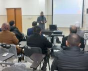
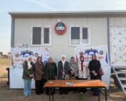
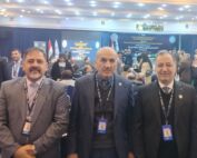
As part of its academic activities and at the invitation of the Skills Development Department at the Nineveh Governorate Diwan, the Remote Sensing Center at the University of Mosul organized a training course entitled “Projecting Project Sites onto Satellite Images” from July 13 to 20, 2025. The course was attended by 62 members from Nineveh Governorate departments. The course aimed to develop participants’ skills in using geodetic systems and spatial analysis. It included lectures on the principles of remote sensing and the importance of satellite imagery in determining project locations, presented by Professor Rayan Ghazi Thanoun. Lectures on dealing with geographic coordinates and their projection onto satellite imagery, with an explanation of the spatial projection of the development line in Nineveh Governorate, presented by Professor Sabah Hussein Ali. Dr. Khansa Abdul-Ilah Ahmed also explained projection tools, spatial analysis, and spatial processing of satellite imagery within Geographic Information Systems (GIS) programs. This course comes within the framework of the University of Mosul’s commitment to raising the efficiency of its cadres